-
开放科学(资源服务)标志码(OSID):

-
修建地铁是缓解城市地面交通压力、提高市民出行质量、彰显城市文化及魅力的重要举措. 地铁大部分位于地面以下,由于施工的原因会对周围土体产生不同程度的影响,可能造成地面塌陷、建筑或构筑物出现不同程度沉降变形,严重的甚至影响地铁施工安全以及地面建筑物或构筑物的使用安全,因此施工中必须对地铁沿线地表沉降进行实时监测.
目前,地铁沿线地表变形监测的主要手段为水准测量和地形测量,但是在大范围的测区中,传统测量方法受到很大限制. 合成孔径干涉雷达测量作为一种新型测量技术,因其精度高、测绘速度快、覆盖范围广等优点在矿山测量、滑坡监测、地表形变测量等方面发挥着至关重要的作用[1-4]. 国内外许多学者利用InSAR技术对地表形变展开监测和研究,如Chen W F等[5]利用28景Radarsat-2数据,基于PS-InSAR技术获取了北京地铁6号线2010年4月至2013年9月期间部分路段的沉降信息,并结合熵值法分析沉降分布的稳定性;范雪婷等[6]利用30景COSMO-Sky Med数据获取了南京市的地表沉降信息,并分析了南京市地铁网络的形变特征;谢文斌等[7]利用17景Sentinel-1数据获取抚顺地区的沉降信息,并结合信息熵对沉降区域的稳定状态进行了评价;刘琦等[8]利用85景Sentinel-1数据,获取了佛山市2015-2018年的地表形变信息,并结合Logistic函数模型预测沉降变化情况. 总体来讲,InSAR技术监测区域多以块状区域监测研究为主,线状区域监测相对较少.
青岛地铁1号线是国内最深且最长的地铁海底隧道,沿线共穿越4组14条断裂带. 受地质条件及施工影响,2019年6月至7月发生2次塌方,造成一定的人员伤亡及财产损失,其他在建地铁线路沿线也屡有沉降现象发生. 青岛地铁工程目前多采用传统方法进行监测,利用InSAR技术对青岛地铁沿线的形变信息监测相对较少. 随着青岛地铁工程的密集建设与发展,对地铁工程沿线地表进行快速、广泛、高效地形变监测极为重要.
本文利用青岛地铁1号线西海岸新区段的29景Sentinel-1A影像数据,采用小基线集技术(SBAS-InSAR)进行处理,获取了2018年5月至2020年5月青岛地铁1号线西海岸新区路段的沉降信息,对沉降重点区域进行了分析.
HTML
-
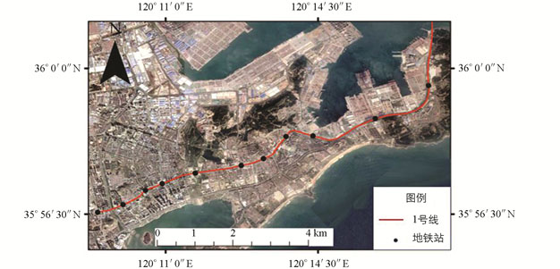
青岛市轨道交通远景年线网共规划16条线路,目前已经通车的有2号线、3号线、11号线、13号线,在建的有1号线、4号线、6号线和8号线,未来5年还将有5号线、7号线、9号线、14号线、15号线相继开工. 青岛地铁1号线于2016年3月全线开工,是一条跨越胶州湾的海底地铁线路,全长约60.14 km,连接西海岸新区和市南区、市北区、李沧区、城阳区5个辖区,总体呈南北走向,划分为南段、中段和北段. 西海岸新区处于北纬35°35′-36°08′、东经119°30′-120°11′,该区位于胶州湾西岸,断裂构造密度相对较低,但北部和东南部断裂分布较密集. 北东向断裂主要分布在新区东南部薛家岛—灵山卫一带,多为胶东半岛上若干规模较大的断裂(如郭城—即墨断裂、王哥庄断裂、沧口断裂等)在胶州湾西岸的延伸,均具有正断层性质,并伴有一定左旋走滑特征,对于地铁建设和运营产生了极大的威胁[9-10]. 本文选择青岛地铁1号线西海岸新区段作为研究对象(图 1),该段隧道已于2020年3月全线贯通,尚未通车.
-
Sentinel-1A是欧洲空间局哥白尼计划于2014年发射的第一颗环境监视C波段卫星,空间分辨率为5 m×20 m,Sentinel-1B于2016年发射,单颗卫星的重访周期为12天,2颗卫星协同工作,重访周期可缩短为6天;其数据具有覆盖范围广、重访周期短、多极化等特点[7]. 本文获取了2018年5月至2020年5月期间青岛市地铁1号线西海岸新区段的29景Sentinel-1A影像数据,详细卫星数据参数见表 1. 此外本文还采用美国国家航空航天局30 m的DEM消除地形相位引起的偏差.
1.1. 研究区概况
1.2. 数据来源
-
小基线集技术(SBAS-InSAR)是2002年由Berardino等[11]提出的一种新的InSAR时间序列分析方法,它克服了传统D-InSAR中存在的时间、空间失相干和大气效应的限制性因素,有效提高了时空的相关性以及去除大气延时相位的影响. 通过对差分干涉图的多视处理降低相位噪声,提取高相干像元,应用奇异值分解法求得影像序列间地表相变速率的最小范数最小二乘解[12-15]. 其基本原理如下:
假设研究区内有N+1幅雷达影像,获取的时间依次为t0,t1,…,tN,选择其中一幅影像作为公共主影像,都能至少与其他一幅影像进行干涉,得到M幅干涉图,满足:
假设在tA和tB时刻获得的2景SAR影像,并已去除地形相位,且tA<tB,最后生成j个干涉对,则像素点(x,r)的干涉相位为:
其中:λ表示雷达波长;d(tA,x,r)和d(tB,x,r)分别为tA和tB时刻像元(x,r)相对于初始时刻t0的方向地表LOS形变,则有:
如果IE=[IE1…IEM]和IS=[IS1…ISM]分别为干涉数据处理时按时间顺序排列的主影像序列,并且满足
则所有的差分干涉图相位可以组成如下观测方程
将公式(5)转换成线性方程
式中,A为m×n维矩阵. 矩阵A的形式取决于图的组织形式,当所有的SAR影像都被分在一组,即L=1时,有M≥N,矩阵A的秩为N,对公式(6)采用最小二乘法即可求解出φ的估计值
$\hat{\varphi}$ -
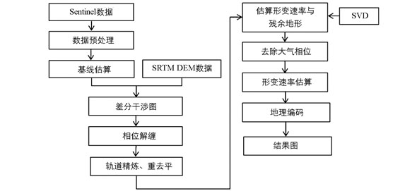
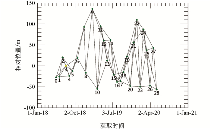
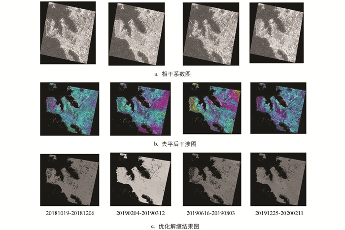
青岛地铁1号线西海岸新区段地表沉降SBAS-InSAR影像处理流程如图 2. 首先将所获得的Sentinel-1A原始数据转换成SLC数据,并对数据进行裁剪预处理,本次试验数据的跨度为2年,将时间基线阈值设置为90 d,选择2019年7月27日的影像作为超级影像,共生成76个干涉对(图 3);采用二轨法进行差干涉,采用Goldstein滤波方法设置相位解缠相干系数为0.35,并利用Delaunay方法进行相位解缠;在解缠后的干涉图中选择20~30相干性较好的点,采用轨道精炼多项式估算相位偏移量,并基于控制点对所有的数据进行重去平,其中部分干涉图和相干系数图如图 4(a)和4(b)所示,采用SVD方法解算得到研究区的形变速率信息和高程. 利用估计的残余地形对干涉图进行去平,并重新解缠和轨道精炼,优化解缠结果,如图 4(c)所示;在第一次估算形变速率基础上进行定制的大气滤波,从而估算和去除大气相位,得到更加纯净的时间序列上的最终位移结果,最后将结果编码到WGS-84坐标系的下,得到平均形变速率图.
2.1. 小基线集技术(SBAS-InSAR)原理
2.2. 数据处理过程
-
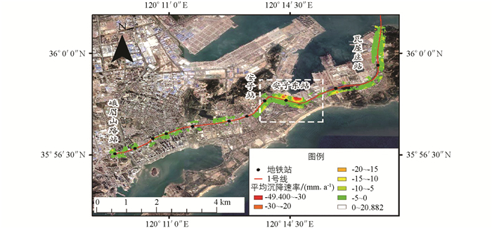
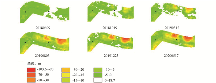
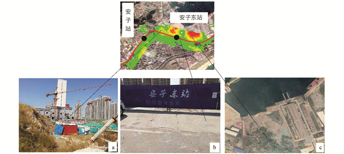
本文选择青岛地铁1号线西海岸新区路段作为主要研究对象,并对沿线两侧构建的600 m的缓冲区域进行分析. 从图 5整体看来,沉降主要集中在地铁站附近,大部分地区的沉降速率为-5~0 mm/a. 沉降严重区域路段的主要沉降区域位于安子站至安子东站区间及附近(白色虚线矩形框内),最大沉降速率达到-49 mm/a,另外本文在29期累积沉降图中选取了6个时间点的累积沉降图,安子站至安子东站区间隧道已于2018年10月全线贯通,从图 6中可以看出在2018年10月19日,研究区的沉降量最大不超过-20 mm,后期随着时间的推移,安子东站东北侧与西北侧的沉降量逐渐增大,可能是由该段的地质情况(该地段位于构造剥蚀区,滨海堆积区[9])和建筑物施工建设所引起,其中安子东站附近的土质大部分为粉质黏土,地铁施工有可能加剧了该地区的地面沉降,但是由地铁建造所引起的大规模沉降的可能性较小. 利用SBAS-InSAR技术获取的青岛地铁1号线西海岸新区段地表沉降监测结果,与传统水准测量监测结果以及地铁1号线西海岸新区部分地段地表沉降现场实勘(如图 7,其中a,b为现场实勘图,c图是获取的谷歌影像图)基本一致.
-
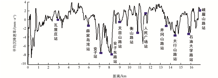
在地铁运行的过程中无论地面沉降还是抬升,都会对轨道的结构产生影响,从而影响到地铁稳定的运营. 为进一步分析地铁沿线的沉降变化情况,本文绘制了从过海处至峨眉山路站地铁中心线的沉降速率剖面图(图 8),从图中可以得出,0点到1 000 m处,沉降速率出现较大波动,变化极快,最大沉降出现在起点位置,沉降速率超过-10 mm/a;其次在安子站至安子东路站附近,沉降呈现出“W”型波动,起伏比较大. 整体来看,青岛地铁1号线西海岸新区段除几处沉降稍显著外,整体沉降比较平稳.
-
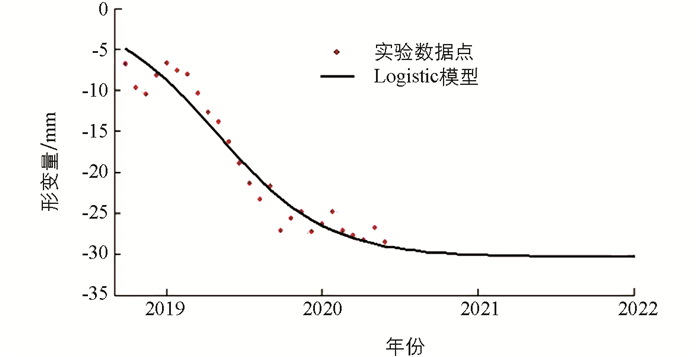
为更好地为青岛西海岸新区地铁施工建设及运行期间制定地表安全预案以及合理开发地下空间提供数据依据,本文利用Logistic函数模型预测地铁1号线西海岸新区段地面沉降趋势. 在隧道开挖完后,logistic函数曲线可以较好地反映地铁隧道沉降的发生、发展及逐渐稳固的长期动态变化过程.
其中:wt表示时刻t的沉降值;参数a和c是模型的2个比例因子;b表示沉降区稳定时最大的沉降值[16]. 本文在安子站至安子东站区间段选择沉降较为严重的点作为预测对象,该区间段于2017年11月下旬动工,于2018年10月实现双线贯通,利用Logistic函数模型对该区间地表沉降趋势作出预测. 从图 9可以看出,自监测日期开始至2020年该点一直处于持续下沉状态,2019年下半年开始,沉降速率开始下降,2020年后沉降逐渐趋于稳定.
3.1. 地铁沿线的沉降监测分析
3.2. 地铁沿线沉降剖面分析
3.3. 地铁沿线的沉降预测
-
本文采用29景Sentinel-1A遥感卫星影像数据,利用SBAS-InSAR技术获取了2018年5月至2020年5月青岛市地铁1号线西海岸新区段的形变信息,发现该路段的主要沉降区域位于安子站至安子东站北侧及附近,最大沉降速率达到约-49 mm/a,最大累积沉降量达到约-103 mm;其他区域的沉降速率为-5~0 mm/a;在0~1 000 m段以及安子站至安子东站段,沉降速波动较大,究其原因与地铁工程施工、地质环境及附近在建工程有必然联系. 结合Logistic函数模型预测安子东站至安子站的路段地面沉降会在2020年后逐渐趋于稳定. SBAS-InSAR技术在青岛地铁1号线西海岸新区段地表形变监测中的成功应用,可以为青岛在建地铁工程及未来规划线路的建设提供有效支持,为城市地下空间开发和运营提供数据辅助决策.




 DownLoad: