Message Board

Dear readers, authors and reviewers,you can add a message on this page. We will reply to you as soon as possible!

2023 Volume 45 Issue 9
Article Contents

LI Tian, LI Huaigang, HE Jianjun, et al. Impact of Different Land Surface Data on Temperature and Precipitation Simulation over Complex Terrain——Take City of Ji'nan as an Example[J]. Journal of Southwest University Natural Science Edition, 2023, 45(9): 124-131. doi: 10.13718/j.cnki.xdzk.2023.09.012
Citation: LI Tian, LI Huaigang, HE Jianjun, et al. Impact of Different Land Surface Data on Temperature and Precipitation Simulation over Complex Terrain——Take City of Ji'nan as an Example[J]. Journal of Southwest University Natural Science Edition, 2023, 45(9): 124-131. doi: 10.13718/j.cnki.xdzk.2023.09.012

Impact of Different Land Surface Data on Temperature and Precipitation Simulation over Complex Terrain——Take City of Ji'nan as an Example

More Information
  • Corresponding author: LI Huaigang ; 
  • Received Date: 15/07/2022
    Available Online: 20/09/2023
  • MSC: P461

  • Ji'nan, the capital of Shandong Province, has a mountainous area in the South and a plain in the north, with significant north-to-south altitudes and complex topographic conditions. To explore the sensitivity of the simulation results of the WRF model to different land surface data, we used MODIS land use and vegetation fraction to replace the default land surface data in the model. We conducted 4 sensitivity experiments to simulate the temperature and precipitation in July 2020 in the Ji'nan area. The simulated temperature and precipitation errors are generally larger in the southern mountainous areas and smaller in the northern plains. Only changing the land use data can significantly reduce the temperature simulation error in the northern plain area (root mean square error, mean bias decreases by 0.2-1.0 ℃ and 0.2-0.8 ℃). Only changing the vegetation fraction data can significantly reduce the simulation error of temperature and precipitation in the southern mountainous area. The simulated temperature root mean square error is reduced by 0.2-1.2 ℃, and the simulated daily precipitation root mean square error is reduced by 0.2-1.2 mm/d. The simulation effect of changing the temperature and precipitation in Ji'nan using both land use and vegetation fraction data is the best. The simulation errors of most stations in the city have been significantly reduced. Compared with temperature, precipitation is more sensitive to vegetation fraction data.

  • 加载中
  • [1] 戴永久. 陆面过程模式研发中的问题[J]. 大气科学学报, 2020, 43(1): 33-38.

    Google Scholar

    [2] KOSTER R D, MAHANAMA S P P, YAMADA T J, et al. Contribution of Land Surface Initialization to Subseasonal Forecast Skill: First Results from a Multi-Model Experiment[J]. Geophysical Research Letters, 2010, 37(2): L02402.

    Google Scholar

    [3] 张井勇, 董文杰, 叶笃正, 等. 中国植被覆盖对夏季气候影响的新证据[J]. 科学通报, 2003, 48(1): 91-95. doi: 10.3321/j.issn:0023-074X.2003.01.023

    CrossRef Google Scholar

    [4] LEI M, NIYOGI D, KISHTAWAL C, et al. Effect of Explicit Urban Land Surface Representation on the Simulation of the 26 July 2005 Heavy Rain Event over Mumbai, India[J]. Atmospheric Chemistry and Physics, 2008, 8(20): 5975-5995. doi: 10.5194/acp-8-5975-2008

    CrossRef Google Scholar

    [5] 韩云环, 马柱国, 李明星, 等. 2001-2010年中国区域土地利用/覆盖变化对陆面过程影响的模拟研究[J]. 气候与环境研究, 2021, 26(1): 75-90.

    Google Scholar

    [6] JEONG J H, SONG S K, LEE H W, et al. Effects of High-Resolution Land Cover and Topography on Local Circulations in Two Different Coastal Regions of Korea: A Numerical Modeling Study[J]. Meteorology and Atmospheric Physics, 2012, 118(1): 1-20.

    Google Scholar

    [7] 张宁, 苏爱芳. 豫西地形对一次强降水过程的影响分析[J]. 气象与环境学报, 2014, 30(6): 16-24.

    Google Scholar

    [8] 张朝林, 苗世光, 李青春, 等. 北京精细下垫面信息引入对暴雨模拟的影响[J]. 地球物理学报, 2007, 50(5): 1373-1382. doi: 10.3321/j.issn:0001-5733.2007.05.012

    CrossRef Google Scholar

    [9] 朱林富, 谢世友, 杨华, 等. 基于MODIS-EVI的四川植被覆盖地形分布特征[J]. 西南大学学报(自然科学版), 2022, 44(9): 122-132.

    Google Scholar

    [10] 于丽娟, 尹承美, 何建军, 等. 植被覆盖度算法对中国区域WRF模拟的影响[J]. 高原气象, 2015, 34(3): 714-721.

    Google Scholar

    [11] 何建军, 余晔, 刘娜, 等. 复杂地形区陆面资料对WRF模式模拟性能的影响[J]. 大气科学, 2014, 38(3): 484-498.

    Google Scholar

    [12] HE J J, YU Y, YU L J, et al. Impacts of Uncertainty in Land Surface Information on Simulated Surface Temperature and Precipitation over China[J]. International Journal of Climatology, 2017, 37(S1): 829-847.

    Google Scholar

    [13] 顾沈旦, 于丽娟, 尹承美, 等. WRF模式对济南地区夏季近地面气象场模拟效果评估[J]. 气象与环境学报, 2016, 32(1): 1-8.

    Google Scholar

    [14] WAN Z, LI Z L. Radiance-Based Validation of the V5 MODIS Land-Surface Temperature Product[J]. International Journal of Remote Sensing, 2008, 29(17/18): 5373-5395.

    Google Scholar

    [15] GUTMAN G, IGNATOV A. The Derivation of the Green Vegetation Fraction from NOAA/AVHRR Data for Use in Numerical Weather Prediction Models[J]. International Journal of Remote Sensing, 1998, 19(8): 1533-1543.

    Google Scholar

    [16] 李恬, 王宏, 赵天良, 等. 山东一次PM2.5污染过程的模拟特征[J]. 气候与环境研究, 2016, 21(3): 313-322.

    Google Scholar

    [17] 何建军, 余晔, 陈晋北, 等. 植被覆盖度对兰州地区气象场影响的模拟研究[J]. 高原气象, 2012, 31(6): 1611-1621.

    Google Scholar

  • 加载中
通讯作者: 陈斌, bchen63@163.com
  • 1. 

    沈阳化工大学材料科学与工程学院 沈阳 110142

  1. 本站搜索
  2. 百度学术搜索
  3. 万方数据库搜索
  4. CNKI搜索

Figures(6)  /  Tables(2)

Article Metrics

Article views(1536) PDF downloads(215) Cited by(0)

Access History

Other Articles By Authors

Impact of Different Land Surface Data on Temperature and Precipitation Simulation over Complex Terrain——Take City of Ji'nan as an Example

    Corresponding author: LI Huaigang ; 

Abstract: 

Ji'nan, the capital of Shandong Province, has a mountainous area in the South and a plain in the north, with significant north-to-south altitudes and complex topographic conditions. To explore the sensitivity of the simulation results of the WRF model to different land surface data, we used MODIS land use and vegetation fraction to replace the default land surface data in the model. We conducted 4 sensitivity experiments to simulate the temperature and precipitation in July 2020 in the Ji'nan area. The simulated temperature and precipitation errors are generally larger in the southern mountainous areas and smaller in the northern plains. Only changing the land use data can significantly reduce the temperature simulation error in the northern plain area (root mean square error, mean bias decreases by 0.2-1.0 ℃ and 0.2-0.8 ℃). Only changing the vegetation fraction data can significantly reduce the simulation error of temperature and precipitation in the southern mountainous area. The simulated temperature root mean square error is reduced by 0.2-1.2 ℃, and the simulated daily precipitation root mean square error is reduced by 0.2-1.2 mm/d. The simulation effect of changing the temperature and precipitation in Ji'nan using both land use and vegetation fraction data is the best. The simulation errors of most stations in the city have been significantly reduced. Compared with temperature, precipitation is more sensitive to vegetation fraction data.

  • 开放科学(资源服务)标志码(OSID):

  • 陆面过程是指发生在陆地表层的所有物理、化学、生物过程及其与大气、海洋的相互作用过程[1]. 人类活动可以改变陆地下垫面的状况并影响陆面过程,进而影响局地或区域的天气状况[2-3]. 陆面过程对近地面气象要素及云降水的模拟会产生较大的影响[4]. 研究陆面过程对提高数值模式的模拟结果精度具有重要意义,而模式中的陆面资料是决定陆面过程的重要因子[5].

    作为中小尺度数值模式,影响天气研究与预报模型(Weather Research and Forecasting,WRF)模式模拟结果的因素有很多,其中复杂地形是影响模拟结果的重要因素[6-8]. WRF模式需要的陆面资料包括土地利用、植被覆盖、地形、土壤类型等,其中土地利用和植被覆盖是陆面过程中最主要的两类陆面资料. 由美国国家航空航天局(National Aeronautics and Space Administration,NASA)发布的中分辨率成像光谱仪(Moderate Resolution Imaging Spectroradiometer,MODIS)地形数据分辨率高,可以代替模式中默认的陆面资料进行模拟研究[9]. 目前,一些学者研究了不同陆面资料对气象要素的模拟影响:于丽娟等[10]使用更高分辨率的植被覆盖资料对中国区域气温和降水进行模拟,发现其有助于改进模式模拟结果. 何建军等[11]利用WRF模式研究了4种陆面资料对兰州地区气象场的模拟影响,发现近地面气温对陆面资料的精度敏感性比风场高;He等[12]替代WRF模式中地形、土地利用、植被覆盖和土壤4种不同的陆面资料对中国地区降水和气温进行模拟研究,发现其日均值和极端值的模拟结果有所提高. 虽然以上研究均得出模拟结果有所改善的结论,但研究范围多为全国或西北地区,对于东部特定区域且地形复杂地区的相关研究很少.

    济南地处中纬度地区,属于暖温带大陆性季风气候区,降水主要集中在每年夏季的7-8月. 该市北部为平原地区,南部为山区丘陵地带,南北纬度、海拔差异大,气象要素差异也较大[13]. 因此,本研究以济南夏季7月的气温和降水两种要素为切入点,将MODIS土地利用和植被覆盖资料替换WRF模式中默认的陆面资料,通过敏感性试验分析了两类陆面资料对济南地区气温和降水的模拟误差. 研究结果将为WRF模拟济南地区的陆面资料提供借鉴意义.

1.   数据与方法
  • 利用WRF模式3.6版本(2015)对济南地区进行模拟. 模式中默认的土地利用资料有两种:一种是由基于MODIS构建的土地利用资料,另一种是由美国地质勘探局(United States Geological Survey,USGS)构建的高级超高分辨率辐射计(Advanced Very High Resolution Radiometer,AVHRR)土地利用资料,资料的最高分辨率为30 s. 本试验选用的默认陆面资料为MODIS土地利用资料. 模式默认的植被覆盖度资料来源于在2001-2010年MODIS数据基础上构建的30 s全球逐月植被覆盖图,但其发布时间较早. 因此利用2020年的MODIS土地利用和植被覆盖数据(https://search.earthdata.nasa.gov)替换模式默认的陆面资料. MODIS土地利用数据(MCD12Q1_v006)是基于国际地圈生物圈计划(International Geosphere Biosphere Programme,IGBP)分类标准处理得到,其空间分辨率为500 m,相较模式默认的陆面数据精度更高,两者在农田和城市地区的分类上也存在较大差异[14]. 替换的植被覆盖度资料是利用2020年7月MODIS植被归一化指数(NDVI,Normalized Difference Vegetation Index)(MOD13A3_v006),使用常用的像元二分模型方法[15]计算得到的. 数据的空间分辨率为1 km,时间分辨率为月. 相较模式默认的植被覆盖资料,该数据时效性更好.

  • 模式的初始场数据为美国国家环境预报中心(National Centers for Environmental Prediction,NCEP)再分析资料,空间分辨率为1°×1°,时间间隔6 h. 模拟时段为2020年7月,该月济南气温和降水接近常年. 模式采用三重嵌套(25 km×5 km×1 km),中心经纬度为117.0°E,36.7°N(图略). 主要的物理参数化方案如下:边界层方案为YSU,微物理过程方案为WSM6,长波辐射方案为RRTM,短波辐射方案为Goddard,陆面过程方案为Noah,积云参数化方案为Grell-3[16]. 分别进行1组基准试验和3组敏感性试验,试验内容如表 1所示. 基准试验和敏感性试验均采用相同的参数化方案进行模拟.

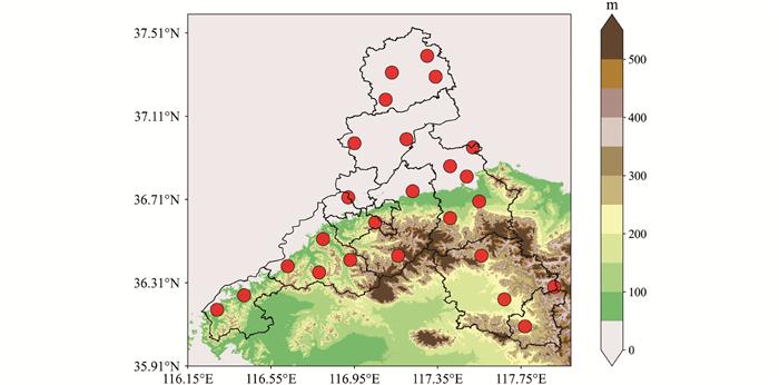
  • 研究将4组试验的模拟值分别与观测值进行模拟评估,选择均方根误差(RMSE)、平均偏差(MB)和相关系数(R)等统计指标进行对比评估[17]. 观测值采用2020年7月济南地区共25个国家气象观测站的逐小时温度和逐日降水量的观测数据,站点分布较均匀,能较好地反映本区域的整体情况. 如图 1所示,济南市的地形呈现南高北低的分布形态,北部地区为平原地区,海拔小于50 m,南部地区为山区,海拔为50~600 m.

2.   结果与分析
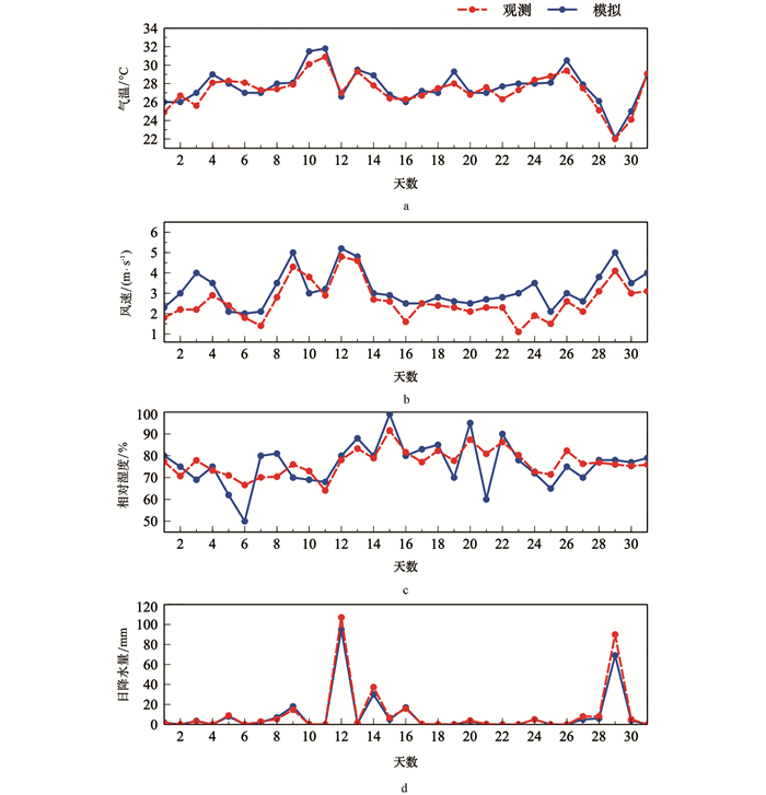
  • 为了确保模拟结果的可靠性,将基准试验模拟的常规观测气象要素与实况进行对比. 对全市25个站点做整体评估,可以反映区域整体的模拟情况. 从各气象要素的模拟误差(表 2)和模拟与观测值的时序图来看(图 2),气温的模拟值与观测值的一致性最好,相关系数为0.81,模拟值较观测值平均偏高0.9 ℃;WRF模式模拟的日降水量较观测值偏小(MB为-3.46 mm/d),但对于13日、29日的历史极端降水的模拟能力不足;模拟的风速整体偏高,模拟与观测的差值最大在2 m/s(图 2b);模拟的相对湿度存在整体偏低的现象(MB为-9.9%),模拟值与观测值的偏差为10%~20%. 在WRF模式可以较好地模拟出该区域气象要素的前提下,后文将对不同陆面资料对模拟误差造成的影响进行分析.

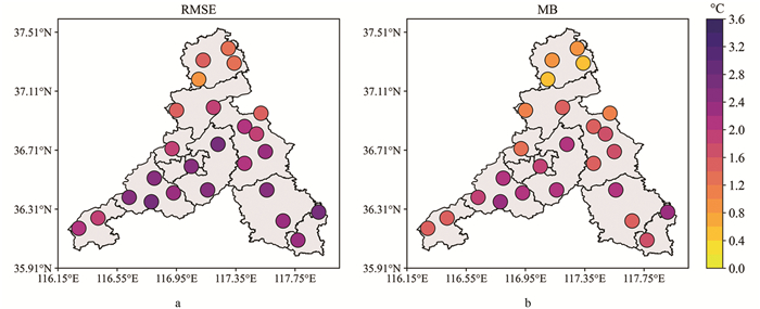
  • 从基准试验模拟的2020年7月济南地区的温度误差分布图中可知(图 3),温度的RMSE波动范围为0.5~3.0 ℃(图 3a),其中北部地区的RMSE相对较小,在0.8~2.0 ℃之间,南部地区的RMSE相对较大,均大于2.0 ℃. 全市范围内MB均大于0(图 3b),说明模拟的温度值均偏高,北部地区MB基本在1.2 ℃以内,而南部地区的MB在1.2~2.0 ℃之间波动. 因此,对于WRF模式基准试验模拟的济南地区温度的空间分布而言,模拟的温度误差南部山区大于北部平原.

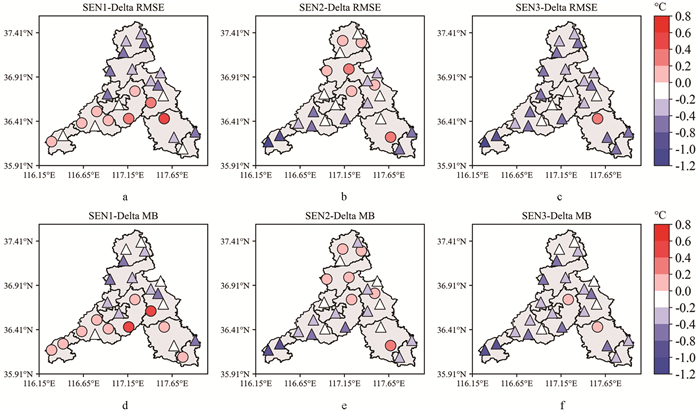
    为了直观地展现每组敏感性试验与基准试验的差别,将敏感性试验各站点的误差值与基准试验的误差值相减(其差值用δ表示,下同),其分布如图 4所示. 三角符号表示敏感性试验的模拟误差较基准试验减小(≤0),圆圈表示增大(>0). 对于只改变土地利用资料的试验而言(图 4a4d),南部山区大部分站点的温度均方根误差没有发生太大变化,而北部地区的误差减小,RMSE减小幅度在0.2~1.0 ℃不等,MB的减小幅度在0.2~0.8 ℃之间;而只改变植被覆盖的模拟试验中南部山区大部分站点的RMSE有明显的减小,误差变化范围减小了0.2~1.2 ℃,北部地区的均方根误差变化不大(图 4b),MB的分布具有相似的规律(图 4e);从同时改变土地利用和植被覆盖资料试验模拟结果(图 4c4f)中可以看到,WRF模式模拟的全市大部分站点的温度误差整体上均有明显的减小(RMSE减小0.7~2.1 ℃,MB减小0.3~1.3 ℃). 综上,对WRF模式模拟济南地区的温度而言,同时改变土地利用和植被覆盖试验的模拟效果最优,其中改变植被覆盖资料对南部山区的误差较北部平原地区明显减小.

  • 日降水量的模拟误差与上文中温度模拟误差具有相似的分布规律:南部的站点误差较北部地区大(其中海拔高的站点误差普遍大). 如图 5a所示,RMSE波动范围为0~15 mm/d,其中北部地区的RMSE相对较小(3~4 mm/d),而南部地区的RMSE相对较大,为6~14 mm/d(东南站点最大达14 mm/d);模式对于北部地区的日降水量值模拟偏高(MB>0),对于南部地区的日降水量值模拟偏低(MB<0,图 5b).

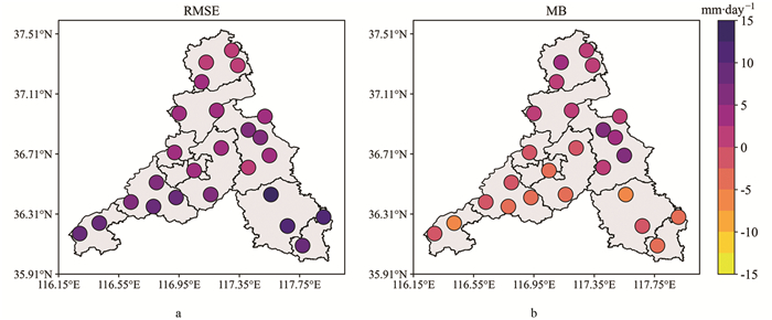
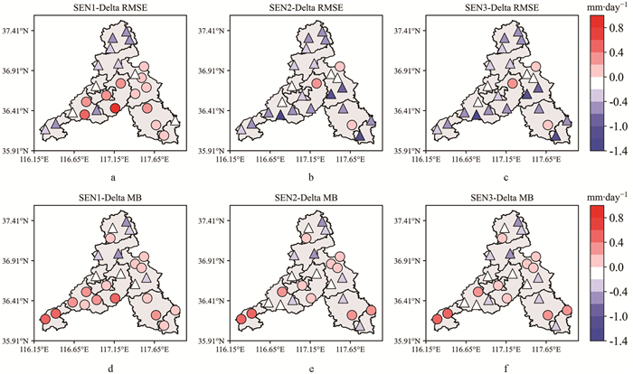
    图 6给出了3组敏感性试验的日降水量误差与基准试验的误差差值分布. 改变土地利用资料对于日降水量的模拟误差规律影响并不明显,RMSE和MB在-0.4~0.4 mm/d之间浮动(图 6a6d);但是只改变植被覆盖资料的模拟试验(图 6b6e),使得南部地区日降水量的RMSE减小了0.2~1.2 mm/d,平均误差减小了0.2~0.6 mm/d;同时改变土地利用和植被覆盖资料模拟结果(图 6c6f)与只改变植被覆盖度的模拟试验结果(图 6b6e)相差不大,即南部地区误差减小,其他地区误差上下浮动,变化不大. 降水对植被覆盖资料的敏感性更好,因此提高WRF模式中植被覆盖资料的精度对降水的模拟具有更好的效果.

3.   结论
  • 本研究基于MODIS土地利用和植被覆盖两类陆面资料,利用WRF模式模拟了济南地区2020年7月的气温和降水,发现模拟误差呈现一定的区域分布特征,得出以下结论:

    1) WRF模式模拟的温度误差南部山区大于北部平原. 同时改变土地利用和植被覆盖资料模拟的济南地区的温度效果最优:全市大部分站点的温度误差都有明显的减小,RMSE减小0.7~2.1 ℃,MB减小0.3~1.3 ℃.

    2) WRF模式对于平原地区日降水量的模拟值偏高,而对于南部山区的日降水量值模拟偏低. 只更新土地利用资料模拟的日降水量误差分布较基准试验变化不大,但只改变植被覆盖资料能够使得山区日降水量的误差明显减小(RMSE较基准试验减小了0.2~1.2 mm/d,MB较基准试验减小了0.2~0.6 mm/d).

    3) 更新WRF模式中的陆面资料有助于提高模式模拟的局限性,其中改变土地利用资料有助于减小北部平原温度的模拟误差,但对降水量模拟误差的减小作用并不大;降水对植被覆盖资料的敏感性比气温好,提高模式中植被覆盖的精度对降水量的模拟具有更好的效果. 同时改变土地利用和植被覆盖资料模拟的温度和降水的效果最好. 本研究忽略了地形偏差等影响模式模拟结果的诸多因素,研究结果仅考虑陆面资料变量的不同,普适性的规律需要进行增加站点数量、扩大区域或增加时间段的模拟研究,以便能进一步提高对模式模拟性能的认识并为提高预报水平提供科学依据.

Figure (6)  Table (2) Reference (17)

Catalog

    /

    DownLoad:  Full-Size Img  PowerPoint
    Return
    Return